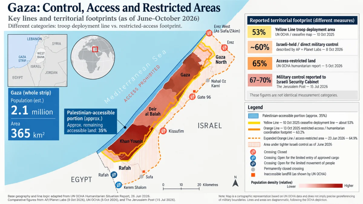
Direct answer: Israel’s military controls just over 60% of the Gaza Strip, according to an October 2026 Associated Press satellite investigation. Israeli-imposed access restrictions cover approximately 65% of Gaza’s land, according to the United Nations. Senior Israeli military officials reportedly told Israel’s Security Cabinet in July that troops controlled 67%–70%. Those are different measurements, not three independent confirmations of the same boundary.
The distinction is consequential. Israel has not formally annexed Gaza, but military occupation does not require annexation, and an absence of formal annexation does not restore a family’s ability to return to a demolished home, cultivate farmland or cross a restricted area. The central, verifiable story is the extent of Israeli military control, enforced exclusion and physical entrenchment on Palestinian land—and the difference between what Israel was supposed to hold temporarily and what it now controls or restricts.
The strongest sources are the UN Office for the Coordination of Humanitarian Affairs (OCHA), reporting in October 2026; the Associated Press satellite investigation published in October; and reporting on the Israeli military’s July estimate to the Security Cabinet.
How much of Gaza is under Israeli control? The numbers
The Gaza Strip covers about 365 square kilometers (141 square miles), according to UK government geographic data. On that basis:
| Reported measure | Share of Gaza | Approximate area | What the figure actually measures |
|---|---|---|---|
| Original October 2025 Yellow Line | 53% | 193 km² / 75 sq mi | Area designated for temporary Israeli troop deployment under the initial ceasefire line, as described by OCHA |
| Netanyahu’s May 2026 statement; consistent with AP’s October description | About 60% | 219 km² / 85 sq mi | Israeli military territorial control; AP describes it as just over 60%, not precisely 60.0% |
| UN access restrictions, October 2026 | 65% | 237 km² / 92 sq mi | Land subject to Israeli-imposed access restrictions; not a census of permanently stationed troops |
| Israeli military assessment reported July 2026 | 67%–70% | 245–256 km² / 94–99 sq mi | Reported military-control estimate from Israeli sources, without a publicly reproduced geospatial map |
Method: SHERAFY.com multiplied each reported share by a 365 km² baseline and rounded the result. These are area equivalents, not independently surveyed parcel boundaries. Sources: OCHA’s June territorial-access account, OCHA’s October update, Netanyahu’s May remarks, AP’s October satellite investigation, and The Jerusalem Post’s July 15 cabinet report.
The most defensible present-tense conclusion is that Israeli forces hold roughly three-fifths of Gaza, while Israel’s wider access-control regime covers about two-thirds. The higher 67%–70% estimate belongs in the story, explicitly attributed and dated; it should not be presented as a precise, independently verified October map.
How much more land is involved than the original ceasefire line?
The original 53% Yellow Line represented about 193 km². If the direct military-control footprint is about 60%, that implies roughly 26 km² (10 square miles) more than the original deployment area. If the reported July 67%–70% military assessment is applied on the same basis, the difference is roughly 51–62 km² (20–24 square miles).
These are comparisons of reported territorial footprints, not a survey proving that a specific number of square kilometers changed hands on a particular date. The sources have different methods and reporting dates.
The UN’s 65% figure is especially easy to misuse. It is about 44 km² (17 square miles) larger than the original 53% footprint, but it measures a broader restricted-access zone, not simply additional land occupied by troops. Counting all of that difference as newly captured military territory would overstate what the evidence proves.
This is why the Yellow Line and Orange Line must be examined separately.
The Yellow Line and Orange Line: how the restricted territory expanded
October 10, 2025 — Yellow Line, approximately 53%. Under the ceasefire arrangement, Israeli forces were to remain temporarily on one side of a withdrawal line covering approximately 53% of Gaza, pending further stages. The line was a military deployment boundary, not a recognized international border.
October 13, 2025 — Orange Line, approximately 63.2%. Just three days later, Israeli authorities gave humanitarian organizations a separate Orange Line map and required advance coordination for movement inside an area covering 63.2% of Gaza. OCHA calculated that the new restrictions extended approximately 36 km² beyond the Yellow Line. This was a substantial expansion of the area governed by Israeli access controls, but it did not itself demonstrate continuous troop occupation of every newly restricted parcel.
March–June 2026 — Restricted area reaches 64.9%. OCHA reported that Israel moved the Orange Line further into Gaza in March, adding approximately 5.5 km² to the restricted area. Its June 26 report placed 64.9% of Gaza under tighter and more direct Israeli control and restrictions. The UN also documented instances in which yellow boundary markers were moved toward populated areas.
May 28, 2026 — An explicit order to expand military control. Prime Minister Benjamin Netanyahu publicly said Israel was controlling 60% of Gaza and that his instruction was to reach 70%. His statement is an unusually direct admission that expanded territorial control was a government objective, separate from the UN’s aid-access mapping. The Times of Israel reported the remarks from video broadcast by Channel 12.
July 15, 2026 — Military estimate of 67%–70%. The Jerusalem Post reported, citing two Israeli sources, that senior officers told the Security Cabinet the Israel Defense Forces (IDF) controlled 67%–70% of Gaza. The article said Netanyahu requested a detailed deployment map. That reported briefing does not substitute for publication of the underlying map and measurement method.
October 2026 — The territorial restrictions persist. In its October 2 situation report, issued October 5, OCHA still described 65% of Gaza’s land as subject to access restrictions. In a separate, early-October satellite investigation, AP placed Israeli military control at just over 60%.
The key chronological finding: The restrictions beyond the initial Yellow Line began almost immediately after the 2025 agreement, while subsequent movements, military construction and Israeli leaders’ statements document a broader effort to increase and consolidate control. The 53% and 65% figures should therefore never be described as two readings of an identical military line.
What has Israel built or destroyed on the territory it holds?
A military boundary on a ceasefire map is reversible in principle. The important question is what is happening on the ground.
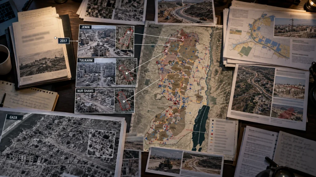
In July 2026, Associated Press analysis of Planet Labs satellite imagery identified more than 23 kilometers (14 miles) of earthen barriers built inside Gaza. The Israeli military confirmed constructing a physical barrier along the Yellow Line and described a security zone intended to prevent infiltration and protect troops and communities near Gaza. AP reported that sections of the earthworks ran through demolished Palestinian communities, and in some places lay outside the nominal Yellow Line.
An October AP satellite investigation identified at least 50 Israeli military outposts across Israeli-held Gaza, including at least 18 established since the ceasefire. Its before-and-after imagery documented extensive demolition and clearing in Rafah, Beit Hanoun, Shijaiyah, Bani Suheila and other areas. It reported that demolition continued after the October 2025 ceasefire.
The Wall Street Journal’s October reporting, including a visit on the Israeli-controlled side, separately described more than 30 fortified bases and military efforts to clear tunnels and buildings. AP and the Journal used different counts and descriptions; their figures should not be added together or treated as a single inventory.
The Israeli military says demolitions and barriers are intended to remove or deny Hamas infrastructure and prevent attacks. Satellite imagery independently establishes the earthworks, outposts and extensive physical destruction. Imagery alone cannot determine the military necessity of every demolition or prove a final decision to retain the land permanently.
Assessment: The physical military footprint is becoming more substantial. Permanent annexation has not been established, but the new barriers, cleared neighborhoods and outposts are concrete evidence of entrenchment, not merely a line on paper.
How much of Gaza remains accessible to Palestinians?
Using the UN’s restricted-access measure, approximately 35% of Gaza—about 128 km² (49 square miles)—remains outside the expanded restricted zone. OCHA says that remaining area is already overcrowded.
That does not mean 35% of Gaza is safe, freely accessible, politically independent or capable of housing everyone. It also does not mean every resident has left the other 65%. OCHA reports that tens of thousands of people have lived in the area between the Orange and Yellow lines, facing uncertain boundaries, pressure to leave, sporadic gunfire and barriers to services.
The constraints affect daily life well beyond military checkpoints. In its June 26 report, OCHA said both of Gaza’s sanitary landfills were inside the restricted area. It also documented impeded access to agricultural land, water and sanitation infrastructure, health and education services, and a prohibition on sea access. Its October report identified lack of accessible land as an obstacle to providing safe sites for displaced residents.
The portion outside direct Israeli military deployment also does not automatically amount to autonomous Palestinian sovereignty. Hamas remains an influential de facto authority in the areas not directly held by Israeli forces, while Israeli controls and military action continue to affect life throughout Gaza. The Associated Press ceasefire assessment published in October describes that continuing division.
Is this occupation, annexation or the seizure of Palestinian land?
Three different questions require three different answers.
Military occupation and effective control: This is about a foreign military exercising authority over territory. Under the International Committee of the Red Cross’s explanation of occupation law, actual effective control—not a declaration of ownership—is decisive. Israel’s military presence, enforced boundaries and own territorial estimates are evidence of effective control over substantial parts of Gaza.
Dispossession and loss of land use: Even without a change in title deeds, residents can be deprived of homes, farmland, return routes and the ability to use their property. OCHA’s access findings and AP’s satellite evidence establish extensive restrictions and destruction. Describing those consequences as territorial seizure and Palestinian dispossession is supported by the observed facts. The precise ownership and military necessity of individual sites would require parcel-level examination.
Annexation: Annexation involves asserting sovereign authority over another territory. Israel has not formally annexed the Gaza Strip. Military fortifications and prolonged exclusion raise questions about de facto permanence, but they are not, alone, proof of a completed legal or administrative annexation.
International law does not allow military occupation to transfer sovereignty. In its July 19, 2024 advisory opinion, the International Court of Justice explained that Israel continued to have occupation-law obligations in Gaza after its 2005 troop and settlement withdrawal, to the extent of its effective control, and reiterated the prohibition on acquiring territory by force. That opinion predates the 2025 ceasefire and is not a judicial finding that any particular 2026 land percentage has been annexed.
The legality of specific property destruction is also a distinct question. Article 53 of the Fourth Geneva Convention generally prohibits an occupying power from destroying public or private property unless absolutely necessary for military operations. Israel offers security and tunnel-related explanations; whether each operation satisfies that strict requirement cannot be determined from a territorial-percentage calculation.
In other words, the absence of formal annexation is not evidence that the land has been returned to civilian use. Conversely, the scale of occupation and demolition does not by itself prove an undisclosed, irrevocable annexation order. These distinctions make the record stronger, not less serious.
Was Israel supposed to withdraw under the ceasefire agreement?
Yes, in stages, subject to agreed security and demilitarization arrangements. The 20-point Gaza plan endorsed by UN Security Council Resolution 2803 (2025) says in point 16 that Israel “will not occupy or annex Gaza” and envisions a progressive handover from the IDF to an International Stabilization Force, while permitting a security-perimeter presence until Gaza is considered secure.
The existence of that conditional security language matters; the agreement did not set an unconditional calendar deadline for the immediate withdrawal of every Israeli soldier. But it also did not describe the Yellow Line as an internationally recognized border or grant Israel sovereignty over the territory behind it.
As the Associated Press reported in October 2026, implementation has stalled amid disputes over Hamas disarmament, Israeli withdrawal and a transitional security administration. Israel links further withdrawal to disarmament; Hamas has linked disarmament to Israeli withdrawal and a halt to attacks. No completed handover of the majority of Gaza is established by the available evidence.
Intelligence assessment: what the evidence does and does not prove
| Finding | Evidence status |
|---|---|
| Israel’s military controls just over 60% of Gaza | Corroborated contemporary reporting — October AP satellite investigation and other reporting |
| 65% of Gaza is covered by Israeli-imposed access restrictions | UN-documented — OCHA October 2026 update |
| Israeli forces controlled 67%–70% in July | Attributed military assessment — reported from two Israeli sources; precise public map unavailable |
| The 2025 53% Yellow Line was followed within days by a broader 63.2% Orange Line access regime | UN-documented chronology — OCHA June 2026 account |
| Outposts, earthen barriers and continuing demolition exist in Israeli-held areas | Independently documented physical evidence — AP satellite investigations |
| Israel has formally annexed Gaza or will retain a fixed share forever | Not established by the evidence reviewed |
Bottom line: Israel has not legally acquired Gaza’s land. But the evidence establishes Israeli military control over more than three-fifths of the Strip, restrictions affecting roughly two-thirds, and extensive demolition and fortification within the territory it holds. The most precise source-backed shorthand is: just over 60% under direct military control; 65% subject to expanded access restrictions; 67%–70% reported by Israeli officers but not independently mapped for October.
That is the scale of the territorial loss of access Palestinians face today. Whether that control becomes lasting annexation is unresolved; the military occupation, physical exclusion and destruction documented by UN records and satellite imagery are not.
References and Further Reading
Territorial boundaries and current UN reporting
- UN OCHA — Humanitarian Situation Report, 2 October 2026 (published 5 October). Confirms continued restrictions affecting 65% of Gaza’s land and overcrowding in the remaining 35%.
- UN OCHA — Humanitarian Situation Report, 26 June 2026. Primary chronology of the 53% Yellow Line, separate Orange Line, subsequent movements and the 64.9% restricted zone.
- UK Government — Overseas Business Risk: The Occupied Palestinian Territories. Source for Gaza’s approximate 365 km² area used in SHERAFY.com‘s conversions.
Israeli statements and independently examined physical evidence
- The Times of Israel — Netanyahu’s May 28, 2026 remarks on expanding to 70%. Reports the prime minister’s public 60%-to-70% instruction.
- The Jerusalem Post — IDF control of 67%–70% reported to Security Cabinet, July 15, 2026. Israeli-sourced claim of territorial military control; not an independent mapped measurement.
- Associated Press — Satellite photos show how Israeli forces have erased Gaza towns, October 2026. Contemporary estimate of just over 60% military control, with imagery of demolitions and at least 50 outposts.
- Associated Press — Israel is building a miles-long earthen barrier inside Gaza, July 2026. Documents over 23 km of earthen barriers and records the Israeli military’s stated security rationale.
- The Wall Street Journal — A Glimpse Inside Gaza Shows How Israel’s Military Footprint Is Expanding, October 2026. Independent reporting from the Israeli-controlled side on fortified military positions and clearance work.
- Associated Press — A year after the Gaza ceasefire, progress has stalled, October 2026. Status of the withdrawal and disarmament impasse.
Agreement text and international law
- UN Security Council — Resolution 2803 (2025), including the 20-point Gaza plan. Text of the staged-withdrawal provisions and the commitment against occupation or annexation.
- International Committee of the Red Cross — Occupation and effective control. Explains how occupation differs from acquisition of sovereignty.
- International Court of Justice — Summary of the July 19, 2024 advisory opinion. Addresses Gaza’s occupation-law obligations and the prohibition of acquiring territory by force.
- ICRC Treaty Database — Fourth Geneva Convention, Article 53. Governing rule on destruction of property by an occupying power and the military-necessity exception.
Editorial currency and method: Research updated October 10, 2026. The article compares dated figures using differing operational definitions; it does not claim a real-time independent measurement of every Israeli deployment position. An updated territorial map or a published IDF map could materially change the precise military-control estimate. All area conversions are approximate.