Last territorial review: September 23, 2026
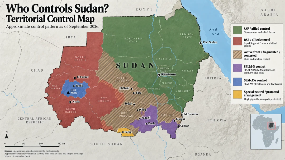
Sudan has no single nationwide controller. The Sudanese Armed Forces, or SAF, and allied forces control Khartoum and most of northern, eastern and central Sudan. The Rapid Support Forces, or RSF, dominate most of Darfur and nearly all of West Kordofan.
But that simple east-versus-west description leaves out much of what is happening on the ground.
The most fluid fronts now run through North Kordofan, South Kordofan and Blue Nile. The Sudan People’s Liberation Movement-North faction led by Abdelaziz al-Hilu controls significant territory in the Nuba Mountains and parts of Blue Nile. The Sudan Liberation Movement faction led by Abdel Wahid al-Nur controls Jebel Marra and Tawila. SAF-aligned Darfur Joint Force formations also operate across parts of northwestern Darfur.
The broad national picture is supported by the UK government’s July 2026 Sudan security assessment, while newer September reporting shows important movement around Kordofan and Blue Nile.
This page uses territorial control to mean practical control on the ground. It does not imply legal sovereignty, international recognition or political legitimacy.
Sudan Territorial Control at a Glance
The cleanest national summary as of September 23, 2026 is:
| Region | Current broad picture |
|---|---|
| Khartoum | SAF-controlled |
| Northern Sudan | Predominantly SAF-controlled |
| Eastern Sudan / Red Sea | SAF-controlled |
| Al Jazirah and central Nile corridor | Predominantly SAF-controlled |
| North Kordofan | Mostly SAF-held population centers, with active RSF positions in the west, northwest and south |
| South Kordofan | Fragmented among SAF, SPLM-N and RSF/SPLM-N-aligned forces |
| West Kordofan | Predominantly RSF-controlled |
| Darfur | Predominantly RSF-controlled, with important SLM-AW and Joint Force exceptions |
| Blue Nile | Split between SAF-held northern/central areas and RSF/SPLM-N-controlled southern and southeastern areas |
The June 2026 national territorial-control map published by Sudans Post remains a useful national baseline. It shows the broad SAF-controlled north and east, RSF-dominated west, SPLM-N territory and SLM-AW territory. But it predates important September changes in North Kordofan and Blue Nile.
That is why a current Sudan control map cannot simply reuse a several-month-old national snapshot.
Who Controls Sudan’s Major Cities Right Now?
The table below separates relatively stable control from front-line or unusual cases.
| Location | State / region | Current control | Confidence | Important qualification |
|---|---|---|---|---|
| Khartoum | Khartoum | SAF / allies | High | SAF controls the capital on the ground |
| Omdurman | Khartoum | SAF / allies | High | RSF drone capability does not equal territorial control |
| Bahri / Khartoum North | Khartoum | SAF / allies | High | Part of the SAF-held capital region |
| Port Sudan | Red Sea | SAF / government | High | Core eastern government territory |
| Wad Madani | Al Jazirah | SAF / allies | High | Al Jazirah returned to SAF control |
| El Obeid | North Kordofan | SAF / allies | High | Major SAF garrison and western staging point |
| Bara | North Kordofan | SAF / allies | High | Recaptured; road east to central Sudan reopened |
| Jabrat al-Sheikh | North Kordofan | SAF / allies | High | Firmly within the current SAF-held eastern belt |
| Sodari town | North Kordofan | RSF | High | Wider Sodari Locality is mixed and increasingly contested |
| Umm Badr | North Kordofan | RSF | High | RSF position in western North Kordofan |
| Hamrat al-Sheikh | North Kordofan | RSF | High | RSF forces remained deployed there in late September |
| Al-Mazroub | North Kordofan | Uncertain / vacated | High for uncertainty | RSF withdrew, but SAF had not entered as of the latest local reporting |
| Kadugli | South Kordofan | SAF | High | SAF-held capital surrounded by more complicated regional control |
| Dilling | South Kordofan | SAF | High | SAF-held city and important road node |
| Kauda | South Kordofan | SPLM-N | High | SPLM-N retook full control after internal fighting |
| Al-Nuhud | West Kordofan | RSF | High | Major RSF-controlled western center |
| Babanusa | West Kordofan | RSF | High | RSF controls the former major SAF garrison |
| Heglig | Oil region | Special security arrangement | High | Sudanese territory under an unusual South Sudanese protection arrangement |
| El Fasher | North Darfur | RSF | High | RSF has controlled the city since October 2025 |
| Nyala | South Darfur | RSF | High | RSF military, logistics and parallel-administration hub |
| El Geneina | West Darfur | RSF | High | Firmly within RSF-dominated western Darfur |
| Tawila | North Darfur | SLM-AW | High | Controlled by Abdel Wahid al-Nur’s Sudan Liberation Movement |
| Jebel Marra | Darfur | SLM-AW | High | Important territory outside the SAF-RSF binary |
| Ed Damazin | Blue Nile | SAF | High | Current coalition offensive has not captured the capital |
| Roseires | Blue Nile | SAF | High | Important government-held center and dam area |
| Kurmuk | Blue Nile | RSF + SPLM-N | High | Coalition-held border town |
| Geissan | Blue Nile | RSF + SPLM-N | High | Coalition-held southeastern area |
| Al-Keili | Blue Nile | SAF / active front | High | SAF still held the position after September fighting |
The table deliberately does not assign a controller to every square kilometer of Sudan. Large rural and desert localities can contain competing movements, lightly held settlements and areas where neither side maintains a meaningful permanent presence.
What Changed in the Latest Sudan Map Update?
Al-Mazroub is no longer safely describable as RSF-controlled, but it is not yet SAF-controlled either
This is one of the most useful examples of why a battlefield map needs an uncertainty category.
In its September 23 bulletin, independent Sudanese outlet Ayin Network reported that local sources said RSF forces had abandoned Al-Mazroub. But the same source specifically said the Sudanese army had not yet entered the town.
The accurate status is therefore:
RSF withdrawn; replacement control not yet established.
Simply recoloring the town as SAF territory would turn an inference into a fact.
SAF has pushed substantially farther west in North Kordofan
A detailed September 22 assessment by Sudans Post mapped the latest North Kordofan front. SAF and allied forces fully controlled five of the state’s eight localities and almost all of Sheikan Locality, while advancing into West Bara and Sodari localities.
Geolocated footage supported SAF presence in several newly claimed locations, including Kajmar, Al-Qa’a, Rishan, Sharshar and Kokweti. But the available visual evidence did not independently verify every place listed in the military’s announcement.
That distinction matters. A military statement is evidence of what the military claims. It is not automatically proof that every claimed town has changed hands.
The RSF still retains important North Kordofan positions
The same September mapping confirms that the RSF still controlled Sodari town, Umm Badr and Hamrat al-Sheikh, while maintaining additional positions west and south of El Obeid.
Sudan Tribune separately reported major RSF concentrations around Hamrat al-Sheikh, Sodari, Umm Badr and Al-Mazroub during the retreat from the SAF offensive.
The correct description is therefore not "SAF captured North Kordofan."
It is:
SAF now controls most of North Kordofan’s major eastern and central population centers, while an active western and southern RSF belt remains.
The Blue Nile front is moving in the opposite direction
In Blue Nile, the RSF and allied SPLM-N forces have expanded northward from the Ethiopian border.
September reporting confirms their control of Kurmuk and Geissan, as well as the Bakkori and Surkum military positions. They have announced additional gains farther north, although some of those newer claims remain independently unverified.
SAF still controls Ed Damazin, the regional capital, and continued fighting around Al-Keili as recently as September 18-19. Sudan Tribune reported that the army repelled another coalition assault there.
Where Are Sudan’s Main Front Lines Right Now?
The main ground front is no longer Khartoum.
The war’s most important moving fronts now form a broad arc from Blue Nile in the southeast through Kordofan and into Darfur in the west. A September 5 Anadolu overview of Sudan’s active fronts similarly identified Blue Nile, Kordofan and Darfur as the principal theaters of current fighting.
North Kordofan: SAF is pushing west from El Obeid
North Kordofan is currently the most important changing front.
SAF holds El Obeid, Bara, Jabrat al-Sheikh, Um Dam Haj Ahmed, Rahad and Um Ruwaba, as well as most of Sheikan Locality. Its September offensive also pushed deeper through West Bara and toward the center of Sodari Locality.
The RSF, however, retains significant positions at Sodari, Umm Badr, Hamrat al-Sheikh, Abu Qa’ud, Umm Sumaima and Kazgil, depending on the exact locality and date.
The distinction between Sodari town and Sodari Locality is particularly important. Geolocated footage placed RSF fighters inside Sodari town even as SAF forces advanced to within roughly 40 kilometers of it.
That is why a map should not color the entire locality based solely on who holds its administrative center.
Why El Obeid and Bara matter
El Obeid is the major military and transport hub linking central Sudan with Kordofan and routes farther west toward Darfur.
SAF’s late-July recapture of Bara, Jabrat al-Sheikh and other points reopened the more direct road between Khartoum/Omdurman and El Obeid. The September offensive has pushed the front farther away from that corridor.
That matters strategically even without calculating territorial percentages. Control of a road connecting major population centers can have more operational significance than nominal control of a much larger stretch of sparsely populated desert.
South Kordofan is fragmented, not SAF- or RSF-controlled as a whole
SAF holds the major cities of Kadugli and Dilling, but the Nuba Mountains contain extensive SPLM-N territory.
The SPLM-N faction led by Abdelaziz al-Hilu also restored control over its longtime stronghold of Kauda in August after fighting with an internal rival faction.
SAF and allied forces have meanwhile pushed along the El Obeid-Dilling axis. Military sources reported the September 17 capture of Al-Farshaya and Al-Mamsouka, though those gains were less independently verified than the geolocated North Kordofan advances.
One useful caution: some current reporting places Al-Mamsouka inconsistently among the Kordofan states. The settlement lies on the western El Obeid-Dilling axis, and any detailed map should normalize its location rather than blindly reproduce conflicting datelines.
West Kordofan remains overwhelmingly RSF-held
The broad national evidence continues to place nearly all of West Kordofan under RSF control.
That includes major centers such as Al-Nuhud, El Fula and Babanusa.
The important exception is the Heglig oil zone, whose status cannot be accurately summarized with a normal RSF color.
After the RSF seized Heglig in December 2025, a tripartite arrangement involving Sudanese army leader Abdel Fattah al-Burhan, South Sudanese President Salva Kiir and RSF commander Mohamed Hamdan Dagalo allowed South Sudanese forces to deploy around the facilities and protect the oil infrastructure. Ayin’s September 23 reporting describes the arrangement as having effectively neutralized the Heglig zone.
Heglig therefore remains Sudanese territory, but its current security arrangement is unusual enough to deserve a separate map category.
Blue Nile: the RSF-SPLM-N coalition is pressing northward
Blue Nile is the other major fast-changing front.
The RSF-SPLM-N coalition controls Kurmuk and Geissan near the Ethiopian border and has captured important army positions at Bakkori and Surkum.
Coalition forces announced additional captures in September around Madal Abiqo, Beli Bong, Kambarda, Dokan, Karn Karn and Khor al-Hassan. Those claims should be labeled as coalition claims unless independently corroborated.
SAF continues to hold Ed Damazin, and its forces remained active around Al-Keili after another September attack.
Drone attacks on Ed Damazin demonstrate that the coalition can strike the capital. They do not demonstrate that it controls the capital.
Who Controls Darfur?
The RSF controls most of Darfur, including its principal state capitals, but it does not control every part of Darfur.
The RSF has controlled El Fasher, the capital of North Darfur, since October 2025. September reporting from Darfur24 confirms continued RSF control and new fortifications around the city.
Nyala remains an RSF military, logistical and administrative center. Darfur24 reported on September 23 that Nyala airport continues to function as an RSF logistics hub despite SAF airstrikes.
But two important exceptions prevent an accurate map from coloring all Darfur as RSF territory.
Jebel Marra and Tawila are controlled by SLM-AW
The Sudan Liberation Movement faction led by Abdel Wahid Mohamed al-Nur, usually abbreviated SLM-AW, remains outside both the SAF and RSF camps.
It controls important territory in Jebel Marra, while Tawila operates under its civilian and security authority. Current September reporting continues to describe both areas as SLM-controlled.
Tawila has also become one of Sudan’s major displacement hubs for civilians fleeing RSF-controlled El Fasher and surrounding areas.
Northwestern Darfur is a moving Joint Force-RSF frontier
The second exception lies near the Chad border.
The SAF-aligned Darfur Joint Force has fought repeatedly with the RSF around Tina, Karnoi and Um Baru. ACLED reports that after RSF offensives in the area, Joint Force formations advanced from the Tina direction and seized multiple villages across North and West Darfur.
That region should therefore be shown as a moving or mixed frontier, not converted into a clean block of SAF territory.
Who Controls Khartoum Right Now?
SAF controls Khartoum, Omdurman and Khartoum North on the ground.
The current national assessment places Khartoum State within SAF-controlled territory following the army’s recapture of the capital region in 2025.
That does not mean the RSF has lost the ability to strike the capital.
Long-range drones have allowed both sides to attack cities far beyond their immediate ground positions. The ability to hit a city with a drone or aircraft must therefore be separated from the question of who controls streets, government buildings and access routes on the ground.
Strike range is not territorial control.
Who Controls Kordofan?
Nobody controls all of Kordofan.
The three Kordofan states now have very different territorial pictures.
North Kordofan: SAF controls most major eastern and central population centers, including El Obeid and Bara, while the RSF retains western, northwestern and southern positions.
West Kordofan: predominantly RSF-controlled, with the special Heglig arrangement as an important exception.
South Kordofan: divided among SAF-held cities, SPLM-N territory in the Nuba Mountains and active fronts involving SAF, RSF and SPLM-N-aligned forces.
Treating "Kordofan" as a single front obscures more than it explains.
Who Controls Blue Nile?
SAF retains Ed Damazin, Roseires and important northern and central positions, while the RSF-SPLM-N coalition controls substantial southern and southeastern territory around Kurmuk and Geissan.
The coalition’s advances have made Ed Damazin a front-line strategic objective, but current evidence does not support describing the regional capital as captured or controlled by the coalition.
That distinction should remain explicit as long as the front continues moving.
Sudan Is Not Simply SAF vs. RSF
The phrase "SAF vs. RSF map" captures the main public search intent, but it is an incomplete description of the actual territorial landscape.
Sudanese Armed Forces and allied groups
The SAF is Sudan’s regular military and controls the country’s principal northern, eastern and central territorial core.
It also fights alongside a range of allied formations, including armed movements from Darfur that make up or participate in the Joint Force.
Rapid Support Forces and allied groups
The RSF controls the principal western territorial bloc, particularly most of Darfur and West Kordofan.
It also operates alongside allied political and armed groups through the Tasis coalition.
SPLM-N, Abdelaziz al-Hilu faction
The SPLM-N faction led by Abdelaziz al-Hilu controls major areas of the Nuba Mountains and territory in southern Blue Nile.
It is allied with the RSF in important current theaters, especially Blue Nile, but that does not make every historical SPLM-N-controlled area simply "RSF territory."
SLM-AW
The Sudan Liberation Movement faction led by Abdel Wahid al-Nur remains independent of both main camps.
It controls territory centered on Jebel Marra and maintains authority around Tawila.
Darfur Joint Force
The Joint Force is composed of armed movements aligned with SAF and has played an increasingly important role in Kordofan, Blue Nile and northwestern Darfur.
On a detailed map, Joint Force control should sometimes be distinguished from direct SAF control, especially where its formations are the primary forces physically holding territory.
Who Governs Sudan Politically?
Territorial control and political authority are related, but they are not the same question.
The SAF-aligned authorities operate Sudan’s existing state institutions from the SAF-controlled side of the country, with government functions increasingly restored in Khartoum.
The RSF and its allies have built a rival Tasis administration centered in Nyala, including ministries, regional institutions and a parallel central-bank structure. The UK government’s current Sudan assessment describes both sides as claiming civilian governing structures while remaining power-sharing arrangements built around armed coalitions.
The African Union has explicitly rejected recognition of the RSF-backed parallel government and has called for Sudan’s territorial integrity to be preserved. The AU reiterated that position in its February 2026 Assembly decision and again emphasized Sudan’s unity and territorial integrity in September.
A territorial-control map therefore answers:
Who exercises practical control here?
It does not answer:
Which authority should be recognized as Sudan’s legitimate government?
Those are different questions.
Who Controls Sudan’s Main Roads and Supply Corridors?
Territorial polygons tell only part of the story.
Khartoum to El Obeid
SAF’s recovery of Bara and Jabrat al-Sheikh reopened the major corridor between the Khartoum region and El Obeid. The September North Kordofan offensive has pushed the closest major RSF ground positions farther west.
El Obeid toward Darfur
West of El Obeid, the picture becomes considerably more difficult.
RSF positions around western North Kordofan and its strong presence in West Kordofan continue to separate the SAF-controlled central core from the RSF-dominated Darfur region.
El Obeid to Dilling and Kadugli
SAF advances around Al-Farshaya and nearby points have strengthened its connection toward Dilling, while large areas of surrounding South Kordofan remain under SPLM-N or contested control.
Ed Damazin to Ethiopia
The Kurmuk and Geissan fronts matter in part because they sit near the Ethiopian border and provide the RSF-SPLM-N coalition with a southeastern territorial foothold from which to pressure Ed Damazin.
Darfur to Chad
The Chad-facing frontier is critical to the northwest Darfur fighting. Joint Force positions around Tina, Karnoi and Um Baru overlap with areas where the RSF has repeatedly mounted offensives and where control can change faster than a national map can reasonably show.
Who Controls Sudan’s Oil and Gold Areas?
Natural resources matter to the war, but the answer is more complicated than "one side controls the oil" or "one side controls the gold."
Oil
Much of Sudan’s remaining oil infrastructure is concentrated toward the south and west, while South Sudan depends on pipelines crossing Sudan to reach the Red Sea.
The unusual status of Heglig illustrates how economic infrastructure can operate under arrangements that do not fit a standard territorial map. After the RSF captured the area, South Sudanese forces deployed to protect the facilities under a negotiated security arrangement.
Ayin reported this month that SAF and RSF forces also cooperated under a security agreement to allow repairs to a damaged South Sudanese crude pipeline.
Gold
The resource map is similarly divided.
The Al Jazeera overview of Sudan’s oil, gold and agricultural resources found that much of northeastern Sudan’s gold-producing territory falls within the SAF-controlled zone, while significant central and western gold areas overlap with RSF-controlled territory.
That makes "who controls Sudan’s gold?" a separate question from "who controls Sudan?"
No one actor controls the entire national gold economy.
Why We Do Not Say SAF Controls Exactly 60% or 65% of Sudan
Some published estimates attempt to assign an exact percentage of Sudanese territory to each side.
A July 2026 Anadolu article quoted one Sudan analyst estimating that SAF controlled somewhat more than 60% of the country and the RSF about 40%.
Those numbers can be useful as a rough description of the overall balance.
They are not precise measurements.
There is no universally accepted method for deciding territorial control across enormous sparsely populated regions where:
- one side may hold the administrative town while the other moves through the surrounding locality;
- neither side maintains a permanent presence across large desert areas;
- a road may be militarily controlled without every adjacent settlement being controlled;
- control may change within days;
- armed groups outside SAF and RSF hold their own territory;
- a force may have strike capability over a location it does not occupy.
For that reason, sherafy.com does not convert the current battlefield into a supposedly exact national percentage.
A location-level evidence ledger is more informative than false decimal precision.
How sherafy.com Determines Who Controls a Location
Battlefield maps become misleading very quickly if every military announcement is treated as established fact.
This tracker uses four practical evidence levels.
High confidence
A location receives a high-confidence assessment when strong current evidence agrees. That can include:
- multiple credible independent reports;
- geolocated imagery;
- satellite evidence;
- authoritative territorial assessments;
- longstanding stable control without credible evidence of a change.
Moderate confidence
Moderate confidence means the available evidence points clearly toward one assessment, but an important limitation remains.
Examples include:
- a recent change confirmed mainly by local sources;
- military imagery that has not been fully geolocated;
- clear control of the main town but uncertainty across the wider locality.
Contested or changing
This category applies where opposing forces maintain meaningful presence around the same location or where control is actively changing.
It should not be converted into whichever color makes the map look cleaner.
Claimed but not independently verified
Military claims can be important evidence.
They remain claims until corroborating evidence establishes that the announced change actually occurred.
The basic rules are:
An airstrike or drone strike does not demonstrate territorial control.
Temporary entry into a village does not necessarily demonstrate sustained control.
Control of a town does not automatically mean control of the entire locality.
An opponent’s withdrawal does not automatically mean the advancing force has occupied the vacated territory.
Military statements are not treated as independent verification of themselves.
Al-Mazroub is the clearest current example. The RSF apparently withdrew, but local reporting said SAF had not yet entered. The evidence therefore supports vacated/uncertain, not an automatic SAF designation.
Sudan Territorial-Control Change Log
This log records meaningful changes rather than silently overwriting older assessments.
| Date | Location / front | Change |
|---|---|---|
| September 23, 2026 | Al-Mazroub | Changed from RSF-held to vacated / control not yet established after reported RSF withdrawal |
| September 17-22, 2026 | North Kordofan | SAF/allied forces pushed farther through West Bara and Sodari localities |
| September 17, 2026 | Sharshar | SAF/allied forces reported and visually supported taking the area |
| September 17, 2026 | Al-Farshaya | SAF/allied forces reported capturing the position on the El Obeid-Dilling axis |
| September 18-19, 2026 | Al-Keili | SAF remained in control after another RSF-SPLM-N assault |
| September 2026 | Kurmuk locality | RSF/SPLM-N announced additional southern Blue Nile gains; several remain independently unverified |
| Late August 2026 | Bakkori / Surkum | RSF-SPLM-N coalition captured important army positions |
| August 2026 | Geissan | RSF-SPLM-N coalition established control |
| Late July 2026 | Bara / Jabrat al-Sheikh corridor | Returned to SAF/allied control, reopening the direct central Sudan-El Obeid route |
| December 2025 | Heglig | RSF seizure followed by special South Sudanese protection arrangement |
| December 2025 | Babanusa | RSF captured the major SAF garrison |
| October 2025 | El Fasher | RSF captured the last major SAF-held city in Darfur |
The older this page becomes, the more valuable that change history becomes. A current map answers who controls a place now. The log answers when and how that changed.
Frequently Asked Questions
Who controls Sudan right now?
No single force controls the whole country. SAF and allied forces control most of northern, eastern and central Sudan. The RSF controls most of Darfur and West Kordofan. Parts of Kordofan and Blue Nile remain actively divided or contested, while SPLM-N and SLM-AW control additional territory outside a simple SAF-RSF split.
Who controls Khartoum?
SAF controls Khartoum and the wider capital region on the ground.
Who controls Omdurman?
SAF controls Omdurman. RSF drone strikes against the capital region do not constitute ground control.
Who controls Darfur?
The RSF controls most of Darfur and its major state capitals, including El Fasher and Nyala. Important exceptions include SLM-AW territory around Jebel Marra and Tawila and the moving Joint Force-RSF frontier in northwestern Darfur.
Who controls El Fasher?
The RSF has controlled El Fasher since October 2025.
Who controls Nyala?
The RSF controls Nyala. The city remains an RSF logistics and political-administrative center despite SAF air and drone attacks.
Who controls El Obeid?
SAF controls El Obeid.
Who controls North Kordofan?
SAF controls most major eastern and central population centers, while the RSF retains important territory and towns farther west, northwest and south. The western front remains active.
Who controls West Kordofan?
The RSF controls most of West Kordofan. Heglig is a special case because South Sudanese forces protect the oil facilities under a negotiated arrangement.
Who controls South Kordofan?
No single force controls the whole state. SAF holds major cities including Kadugli and Dilling, while SPLM-N controls substantial Nuba Mountains territory and additional fronts remain active.
Who controls Blue Nile?
SAF controls Ed Damazin and other principal northern/central areas. RSF and allied SPLM-N forces control Kurmuk, Geissan and other territory closer to the Ethiopian border.
Is Sudan effectively split into two countries?
Sudan is territorially and institutionally fragmented, but it has not become two internationally recognized countries.
The RSF-backed Tasis coalition operates a rival administration from Nyala, but the African Union has rejected recognition of a parallel government and continues to affirm Sudan’s unity and territorial integrity.
Does SAF control most of Sudan?
SAF appears to control more national territory and most of the country’s northern, eastern and central population centers, but sherafy.com does not assign a precise percentage because definitions of control vary substantially across rural and contested areas.
Who controls Sudan’s oil fields?
Control is divided. Many southern and western oil areas lie in RSF-dominated territory, while the pipeline and export system crosses multiple areas before reaching SAF-held Port Sudan. Heglig operates under a special protection arrangement involving South Sudanese forces.
Who controls Sudan’s gold mines?
Neither side controls all of Sudan’s gold. Large northeastern gold-producing areas are within the SAF-controlled zone, while important western and southwestern gold regions overlap with RSF-controlled territory.
What territory does SPLM-N control?
The Abdelaziz al-Hilu faction controls substantial territory in the Nuba Mountains of South Kordofan and areas in southern Blue Nile. It is currently allied with the RSF on important fronts but remains a distinct armed organization.
How current is this map?
The territorial assessment on this page was last comprehensively reviewed on September 23, 2026.
Fast-moving positions should be treated according to the date attached to the underlying evidence, not assumed to remain unchanged indefinitely.
Bottom Line
Sudan’s war is often reduced to a simple map: SAF in the east, RSF in the west.
At the national level, that is a useful first approximation.
It is not enough to understand the battlefield.
SAF controls Khartoum and most of Sudan’s northern, eastern and central core. The RSF controls most of Darfur and West Kordofan. North Kordofan is moving westward in SAF’s favor but remains unfinished. South Kordofan is fragmented among SAF, SPLM-N and other forces. Blue Nile has moved in the opposite direction, with RSF-SPLM-N forces controlling important southeastern territory while SAF holds Ed Damazin. Jebel Marra and Tawila remain outside both principal camps.
The important question is therefore not merely "Who controls Sudan?"
It is:
Who controls each important place, how recently was that verified, and how confident is the evidence?
That is the standard this tracker uses.
References and Further Reading
National Territorial Control and Security Assessments
Country Policy and Information Note: Security Situation, Sudan, July 2026 — UK Government The strongest recent national synthesis used here for the broad territorial division among SAF, RSF, SPLM-N, SLM-AW and other forces.
Territorial Control Map: Sudan Conflict, June 21, 2026 — Sudans Post Useful national map baseline showing the main force blocs before subsequent September battlefield changes.
Mapping Sudan’s War: Who Controls What? — Anadolu Agency July 2026 overview of national control and the shift of the main front toward Kordofan. Also illustrates why percentage estimates should be treated as rough approximations.
North and South Kordofan
Map: Who Controls What in North Kordofan? — Sudans Post September 22 territorial assessment combining field reporting and geolocated footage. Particularly useful for distinguishing independently supported SAF advances from unverified military claims.
Ayin Weekly Bulletin, September 23, 2026 — Ayin Network Provides the key local-source report that RSF withdrew from Al-Mazroub but SAF had not yet entered, as well as current information on the oil-pipeline security arrangement.
Sudanese Army Takes Control of Areas in North and South Kordofan — Anadolu Agency September 17 reporting on the Al-Farshaya, Al-Mamsouka and Sharshar advances, based primarily on military sources and therefore used with appropriate qualification.
SPLM-N Retakes Full Control of Kauda — Sudan Tribune Documents the restoration of SPLM-N control over its Kauda stronghold following internal fighting.
Blue Nile
Sudan’s Army Repels Joint Attack in Blue Nile — Sudan Tribune September 19 reporting confirming continued SAF presence at Al-Keili and the broader RSF-SPLM-N advance from Kurmuk and Geissan.
Clashes Erupt as Rebel Alliance Advances Toward Ed Damazin — Sudan Tribune Provides the current territorial context around Kurmuk, Geissan, Bakkori, Surkum and the approach to the Blue Nile capital.
RSF-SPLM-N Alliance Claims Fresh Gains in Blue Nile — Radio Tamazuj Useful for tracking the coalition’s more recent claims while preserving the distinction between claimed and independently verified territorial changes.
Darfur
RSF Tightens Restrictions Around El Fasher — Darfur24 Current local reporting confirming continuing RSF control of El Fasher.
Nyala Airport Strike Disrupts RSF Deployment Flight — Darfur24 Current evidence of Nyala’s continued role as an RSF logistical hub.
Disabled War Victims Face Dire Conditions in Tawila — Darfur24 Confirms SLM-AW authority in Tawila and helps establish an important territorial exception to RSF dominance in Darfur.
Where Is Sudan’s Frontline Moving Next? — ACLED Detailed analysis of the RSF-Joint Force battles around Tina, Karnoi and Um Baru and the changing northwestern Darfur front.
Political Control and Recognition
African Union Assembly Decision 978, February 2026 — African Union Official AU decision rejecting recognition of the RSF-backed parallel government and affirming Sudan’s territorial unity.
African Union Quad and Quintet Meeting on Sudan, September 23, 2026 — African Union Current AU statement reiterating Sudan’s unity, sovereignty and territorial integrity.
Resources and Infrastructure
Sudan Has Vast Oil, Gold and Agricultural Resources. Who Controls Them? — Al Jazeera Useful visual and data overview of the overlap between territorial control, oil infrastructure, gold deposits and agricultural regions.
Editorial currency note: Sudan’s front lines remain active. Locations marked contested, changing or uncertain may change faster than national assessments can be updated. The control table should be reviewed whenever credible evidence establishes a meaningful territorial change.