

At most major airports, an arriving aircraft follows a stable, largely straight approach toward a runway that pilots can identify well before touchdown.
Landing at Paro International Airport in Bhutan is different.
Pilots descend through a narrow Himalayan valley, remain visually clear of steep terrain, follow a curved flight path and align with the runway relatively late in the approach. The airport has no conventional instrument landing system, no visual glide-slope indicators such as PAPI or VASI, and no runway lights available to guide aircraft during the final approach. Flights are therefore conducted in visual meteorological conditions and during daylight operating hours.
These conditions make Paro one of the world’s most technically demanding commercial airports.
That does not, however, mean aircraft are routinely landing in uncontrolled or reckless circumstances. Paro is difficult precisely because its geography leaves less room for improvisation. The risk is managed through strict operating limits, specialized pilot preparation, weather requirements and airport-specific procedures.
The better description is not simply that Paro is “dangerous.”
It is that Paro demands an unusually high level of preparation, precision and judgment from the pilots permitted to fly there.
Paro Airport quick facts
| Detail | Paro International Airport |
|---|---|
| Location | Paro Valley, Bhutan |
| IATA code | PBH |
| ICAO code | VQPR |
| Airport elevation | Approximately 2,235 meters or 7,334 feet above sea level |
| Runway | One asphalt runway, designated 15/33 |
| Published runway dimensions | 2,265 meters by 30 meters |
| Runway lighting | No runway lights available on final approach |
| Instrument landing system | None |
| Radar at the airport | None |
| Normal flight conditions | Visual meteorological conditions |
| Operating period | Daylight hours, broadly sunrise to sunset |
| Primary challenge | Curved visual approach through steep mountainous terrain |
Bhutan’s current aeronautical publication lists the runway as 2,265 meters long and 30 meters wide. The published airport chart places the aerodrome elevation at approximately 2,235 meters above mean sea level.
Why is Paro Airport so difficult?
Paro is challenging because several demanding factors exist at the same airport:
- The airport sits inside a confined mountain valley.
- High terrain prevents a normal, long, straight final approach.
- The final approach track is curved.
- Pilots must operate visually around the airport.
- The runway lacks an ILS, PAPI, VASI and final-approach runway lighting.
- Wind and turbulence can change within the valley.
- The airport operates at a high elevation.
- Pilots need airport-specific preparation or support.
- Some terrain can obstruct the control tower’s view of aircraft.
- Departures are also constrained by terrain.
None of those factors alone is unique. Airports around the world have short runways, high elevations, strong winds or nearby mountains.
What makes Paro unusual is the combination.
1. Paro Airport is surrounded by steep Himalayan terrain
Paro International Airport lies beside the Pa Chhu River in a deep valley near the town of Paro. Bhutan’s Department of Air Transport describes it as being cradled within that valley, rather than situated on an open coastal plain or broad plateau.
For pilots, terrain changes the geometry of an arrival.
At a conventional airport, an aircraft may intercept a straight final-approach course several miles from the runway. This gives the crew time to stabilize the airplane’s direction, descent rate, speed and configuration.
At Paro, the surrounding hills and mountains limit where an aircraft can safely fly. Pilots cannot simply point the aircraft at the runway from a great distance and descend along an unobstructed line.
They must follow the available valley.
The Bhutan Aeronautical Information Publication explicitly warns of “high terrain and steep mountains adjacent to the aerodrome.” It also states that the normal circuit is generally west of the airport and that the Dopshari Valley to the north or northeast is unsafe and not permitted for circuit operations.
That is a critical distinction.
Paro is not merely an airport with attractive mountains in the distance. The terrain directly determines where aircraft may maneuver.
2. The approach is curved instead of straight
One of Paro’s defining features is its curved final approach.
Bhutan’s official flight procedures state that the final approach track for both runway directions is curved because of hilly terrain. The same publication warns pilots to exercise caution and notes that the final approach is steeper than a conventional three-degree glide path.
A simplified comparison looks like this:
Conventional vs Terrain-constrained Paro approach
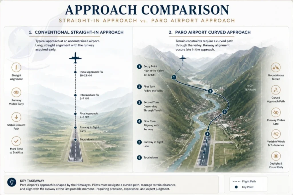
This simplified diagram should not be treated as an operational chart. It illustrates the basic difference: the airplane follows the valley and turns toward the runway rather than remaining established on one long straight line.
During a curved approach, pilots must simultaneously manage:
- Bank angle
- Heading
- Descent rate
- Airspeed
- Terrain clearance
- Aircraft configuration
- Wind corrections
- Runway alignment
The workload is concentrated into a relatively short period.
The airplane must not only reach the runway. It must arrive correctly aligned, at an acceptable height, at a controlled speed and in a stable landing configuration.
3. Pilots line up with the runway unusually late
The terrain around Paro means that pilots may not achieve conventional runway alignment until late in the descent.
That is one reason videos of Paro landings appear so dramatic. Passengers can see hillsides, buildings and terrain through the windows while the aircraft is still turning. The runway may not sit directly ahead until the closing stages of the approach.
Jet Aviation pilots who operated a charter flight into Paro described descending by reference to recognizable terrain features, including ridges and temples. One captain explained that the crew needed to become visual with the valley and use those references to continue descending.
This is not the same as pilots guessing where the airport is.
The flight is planned, briefed and conducted according to established procedures. The important point is that the final segment depends heavily on visual recognition, aircraft handling and local operational knowledge.
At an airport with an instrument landing system, electronic guidance can continuously indicate whether an aircraft is left or right of the desired course and above or below the intended descent path.
Paro does not provide that kind of conventional precision-approach guidance on final.
4. Paro has no ILS, PAPI or VASI on final approach
The absence of familiar landing aids is one of the clearest reasons Paro requires specialized preparation.
Bhutan’s official aeronautical publication states that the airport has no:
- Instrument Landing System, or ILS
- Precision Approach Path Indicator, or PAPI
- Visual Approach Slope Indicator, or VASI
- Runway lights available on final approach
It also states that the final approach is above a standard three-degree glide path.
What does an ILS normally do?
An ILS provides two primary forms of guidance:
- Localizer guidance, showing whether the aircraft is left or right of the runway centerline
- Glide-slope guidance, showing whether the aircraft is above or below the intended descent path
At suitably equipped airports and with an appropriately equipped aircraft and crew, an ILS can support operations in reduced visibility. Some combinations can also support automatic landing.
Paro does not offer that conventional straight-in landing environment.
What do PAPI and VASI lights do?
PAPI and VASI systems give pilots a visual indication of their vertical position relative to a preferred approach slope.
At many airports, a pilot sees combinations of red and white lights:
- Too many white lights can indicate that the aircraft is high.
- Too many red lights can indicate that it is low.
- A balanced combination indicates that the aircraft is near the intended path.
Paro’s published procedures state that these visual glide-path systems are not available on final.
Pilots must therefore rely on their training, aircraft instruments, the published procedure, visual references and continuous judgment of the airplane’s position.
5. Flights around Paro require visual meteorological conditions
Aircraft may operate under an instrument flight plan while traveling toward Bhutan, but the airport environment itself requires visual conditions.
The official airport publication specifies that flights within the Paro traffic circuit must be conducted in visual meteorological conditions, commonly abbreviated as VMC. It further explains that because of the surrounding terrain, only flight in VMC is permitted around the aerodrome.
In practical terms, pilots must be able to see the terrain and the visual references needed to navigate through the valley.
Clouds that would be manageable at an airport with a fully supported straight-in instrument approach may make a Paro arrival unacceptable.
This helps explain why a Paro flight can be delayed, diverted or canceled even when the weather does not look severe to a passenger on the ground.
Rain alone is not necessarily the decisive factor. The more important questions include:
- Can the crew maintain the required visual references?
- Are clouds obscuring the valley or ridges?
- Is visibility sufficient along the approach?
- Are winds and turbulence within acceptable limits?
- Can the entire approach be completed safely?
The airport’s official quick facts state that flights are permitted only under visual meteorological conditions and are restricted to daylight hours.
6. Paro normally operates only during daylight
Paro’s published hours are broadly from sunrise to sunset, rather than around the clock.
The daylight limitation is not an arbitrary scheduling preference. It follows logically from the nature of the approach.
Pilots need to identify terrain and visual reference points. The final approach lacks the runway and approach-lighting environment found at large international hubs. A nighttime arrival would remove many of the visual cues on which the operation depends.
Even a clear night is not equivalent to clear daytime conditions in mountainous terrain.
In darkness:
- Unlit terrain can disappear into the background.
- Depth perception becomes less reliable.
- Hillsides may be difficult to distinguish from empty sky.
- Visual reference points can become ambiguous.
- A phenomenon known as a “black-hole” visual illusion can distort a pilot’s perception of height and distance.
Paro’s daylight restrictions therefore form part of the airport’s safety system.
7. Wind and turbulence can change inside the valley
Mountain valleys can produce localized winds that differ substantially over short distances.
Bhutan’s official procedures warn that:
- Surface winds can vary at different positions along the runway.
- Wind intensity usually increases during the afternoon.
- Aircraft may experience severe turbulence while entering the valley.
- Strong afternoon anabatic winds between February and May can produce moderate to severe turbulence.
- Morning operations are recommended when those conditions are expected.
What is an anabatic wind?
An anabatic wind is an upslope flow produced when the sun heats a mountain slope. The warmer air rises along the terrain.
In a confined valley, these local flows can interact with the broader wind, creating:
- Updrafts
- Downdrafts
- Turbulence
- Crosswinds
- Wind changes along the runway
- Different conditions at opposite ends of the airport
This matters because an aircraft on final approach is already turning, descending and aligning in a constrained area.
A changing wind can alter the aircraft’s:
- Ground track
- Bank required to hold the path
- Descent rate
- Airspeed trend
- Touchdown point
Pilots must anticipate those changes rather than reacting late.
8. Paro’s elevation affects aircraft performance
Paro Airport sits at approximately 2,235 meters, or about 7,334 feet, above sea level.
At higher elevations, atmospheric pressure and air density are lower than at sea level.
This has several operational consequences.
Higher true airspeed
An aircraft’s indicated approach speed may remain within its calculated target range, but its true speed through the surrounding air is higher at altitude.
That generally means the aircraft covers more ground during the same amount of time.
Higher groundspeed
Depending on wind and atmospheric conditions, an aircraft may cross the runway threshold at a greater groundspeed than it would at a sea-level airport.
Greater groundspeed can increase the distance traveled during:
- The flare
- Touchdown
- Deceleration
- A rejected landing or go-around transition
Reduced engine and aerodynamic performance
Lower air density can reduce engine thrust and aerodynamic performance, although the exact effect depends on aircraft type, engine design, temperature, weight and other variables.
Modern airliners calculate these factors carefully. The challenge is not that the airplane becomes uncontrollable. It is that performance margins and runway calculations must reflect the airport’s elevation and conditions.
Density altitude
Pilots use the concept of density altitude to describe how the atmosphere affects aircraft performance.
On a hot day, the effective performance altitude can be substantially higher than the airport’s physical elevation. An airport at roughly 7,300 feet can behave, from the aircraft’s perspective, as though it were even higher.
At Paro, this performance environment exists alongside terrain restrictions and a curved approach.
9. Paro does not have local radar facilities
Bhutan’s current aeronautical publication states that no radar facilities are available at Paro Aerodrome.
Air traffic control still provides essential services, including clearances, communications, traffic management and weather information. The absence of airport radar does not mean the operation is uncontrolled.
It does mean that controllers do not have the same surveillance picture available at a large radar-equipped international hub.
Terrain adds another limitation. The official procedures warn that aircraft flying the descending circuit west of the airport may not always be visible from the control tower because hills can obstruct the line of sight.
Pilots must therefore make accurate position reports and maintain reliable communication.
The airport’s procedures require two-way radio communication on the published tower frequency and set out designated reporting and entry arrangements.
10. Departing Paro is also difficult
Paro’s reputation focuses on landing, but takeoff is not necessarily simple.
A departing aircraft must climb away from an elevated airport while remaining visually clear of terrain. Bhutan’s publication states that Paro has no established Standard Instrument Departures, or SIDs, and that departures must follow visual meteorological conditions. Pilots are instructed to maintain visual separation from terrain and obstacles while initially climbing toward 18,000 feet.
At a typical major airport, a SID provides a coded instrument route from the runway into the en-route airspace system.
At Paro, the local terrain makes a conventional departure structure more difficult.
Before takeoff, crews must consider:
- Aircraft weight
- Temperature
- Runway condition
- Wind
- Climb performance
- Engine-out performance
- Terrain-clearance strategy
- Weather along the valley
- Available diversion or return options
A successful landing is only half of the challenge. The aircraft must later leave the valley safely.
Do pilots need special training to land at Paro Airport?
Yes. Paro is treated as an airport requiring airport-specific preparation.
Bhutan’s official flight procedures state that, before operating into Paro, the pilot in command should have been briefed and visited the aerodrome as an observer, completed instruction in an authority-approved simulator or requested a guide pilot or navigator through an authorized agent.
Jet Aviation describes Paro as a Category C airport, meaning that crews require specific training or must be accompanied by a navigator in the jump seat. For one charter operation, its pilots reported spending approximately a month preparing for the flight.
Airport categorization is used to reflect operational complexity. A Category C designation generally signals that crews need more than a routine airport briefing.
Preparation may include:
- Studying terrain and airport charts
- Learning visual reporting points
- Reviewing runway-specific approach paths
- Simulator training
- Observing the airport from the flight deck
- Flying with a qualified training captain or navigator
- Practicing go-around and abnormal scenarios
- Reviewing aircraft-specific performance
- Learning local weather patterns
- Demonstrating proficiency before receiving operational approval
The exact qualification process can differ among regulators, airlines, aircraft types and private operators.
How many pilots are qualified to land at Paro?
This is one of the most frequently repeated—and least reliably reported—facts about the airport.
Articles have variously claimed that only eight, twelve, two dozen or roughly fifty pilots are qualified to land at Paro. Those numbers often circulate for years without a date, official roster or clear definition of “qualified.”
The number can change as pilots:
- Complete training
- Change airlines
- Change aircraft types
- Lose recency
- Retire
- Move into management
- Renew or discontinue airport authorization
There is also a difference between:
- Pilots employed by Bhutanese scheduled airlines
- Foreign charter pilots approved for a specific operation
- Training captains
- Pilots current on one aircraft type but not another
- Pilots accompanied by an approved guide or navigator
The accurate answer is therefore:
Only pilots who meet Paro-specific operational requirements may act in command of an arrival there, but no durable public number should be repeated without a dated, authoritative source.
The scarcity is real. The viral numerical claims are not consistently verifiable.
That distinction matters because an article should not convert an old media estimate into a permanent aviation fact.
Is Paro Airport dangerous?
Paro is better described as challenging and tightly controlled than casually labeled “the world’s most dangerous airport.”
The word dangerous attracts clicks, but it can misrepresent how commercial aviation manages risk.
Paro presents genuine hazards:
- High terrain
- Curved approaches
- Limited visual maneuvering space
- Rapidly changing weather
- Turbulence
- High elevation
- Limited landing aids
- Daylight and visibility dependence
But those hazards are known.
The aviation system responds by limiting who may operate there, when flights may occur and under what weather conditions.
This distinction is fundamental:
A difficult airport can be operated safely when its risks are understood, crews are properly trained and conservative limits are enforced.
Paro does not become safe because the mountains disappear. It becomes manageable because airlines, pilots, controllers and regulators refuse to treat it like an ordinary airport.
Delays and diversions are not failures of that system. They are evidence that the system is enforcing its boundaries.
What happens if a Paro approach becomes unstable?
A landing approach is expected to meet defined stability criteria. Although exact airline policies differ, a stable approach generally requires the aircraft to have an appropriate:
- Flight path
- Landing configuration
- Airspeed
- Descent rate
- Power setting
- Checklist status
If the aircraft is not stable, the crew should discontinue the approach.
This maneuver is called a go-around.
During a go-around, pilots:
- Apply the required thrust.
- Stop the descent.
- Establish a climb.
- Reconfigure the aircraft in stages.
- Follow the required missed-approach or visual escape procedure.
- Decide whether to attempt another landing, hold, divert or return.
At Paro, the surrounding terrain makes go-around planning especially important. It is not simply a matter of climbing straight ahead without considering the valley.
The crew must brief the relevant path before beginning the approach.
A go-around is not an admission that the pilot lacks skill. Refusing an unstable landing is one of the clearest signs of professional judgment.
Can an airplane land automatically at Paro Airport?
Not through the conventional autoland process used at suitably equipped ILS airports.
Autoland generally requires compatible:
- Ground-based approach equipment
- Aircraft systems
- Runway infrastructure
- Crew qualifications
- Weather and operating approvals
Paro has no ILS and requires a curved visual approach in the local airport environment. Its official procedures also state that no PAPI, VASI or runway lights are available on final.
Modern aircraft can still use advanced navigation, terrain-awareness systems, flight-management computers and other electronic tools. Those systems improve situational awareness and help crews manage the approach.
But they do not turn Paro into a hands-off automatic landing.
The pilots remain responsible for visually navigating, maneuvering, aligning and landing the aircraft.
Why does the Paro landing look so close to houses and hills?
Videos from inside arriving aircraft can make the airplane appear extraordinarily close to buildings and slopes.
Several factors intensify that impression:
- The aircraft is flying inside a valley rather than high above open terrain.
- Hillsides rise toward the aircraft’s altitude.
- The airplane must bank during the descent.
- Wide-angle phone lenses can exaggerate perspective.
- Passengers see terrain through side windows during turns.
- Buildings provide a familiar scale that makes the aircraft’s height easier to perceive.
The approach is genuinely terrain-constrained, but video can make distances difficult to judge accurately.
Jet Aviation pilots described using ridges, temples and other visible landmarks while descending into the valley. One described the final portion as appearing close enough to observe details in nearby homes, illustrating how visually immersive the approach can feel from the cockpit.
Is Paro Airport harder than Lukla Airport?
Paro and Lukla are frequently compared, but they present different problems.
| Feature | Paro International Airport | Tenzing–Hillary Airport at Lukla |
|---|---|---|
| Typical traffic | Commercial jets, turboprops and other approved aircraft | Primarily smaller turboprops and helicopters |
| Main challenge | Curved valley approach, high terrain and visual maneuvering | Very short, sloped runway and restrictive terrain |
| Runway length | More than two kilometers | Far shorter |
| Approach style | Curved approach through a valley | Confined approach toward a short mountain runway |
| Go-around considerations | Terrain-dependent and procedure-sensitive | Extremely limited once committed |
| Aircraft size | Can accommodate selected commercial jets | Primarily smaller aircraft |
Calling one definitively “harder” oversimplifies the comparison.
Lukla’s short runway and restrictive geometry create an exceptionally small operating envelope. Paro allows larger aircraft and has a longer runway, but requires crews to maneuver a heavier, faster airplane through a complex valley environment.
A more accurate conclusion is:
- Lukla is more runway-constrained.
- Paro is more complex as a commercial jet approach.
Both require specialized experience.
How Paro compares with other difficult airports
| Airport | Principal challenge |
|---|---|
| Paro, Bhutan | Curved visual approach through high Himalayan terrain |
| Lukla, Nepal | Short, sloped runway with restrictive terrain |
| Madeira, Portugal | Wind, turbulence and terrain near the runway |
| Innsbruck, Austria | Alpine terrain and specialized approach procedures |
| London City, United Kingdom | Steep approach and short urban runway |
| Courchevel, France | Short, steeply sloped mountain runway |
| Queenstown, New Zealand | Mountainous terrain and complex weather |
| Gibraltar | Constrained geography and frequent crosswinds |
| St. Maarten | Low approach over a public beach |
Paro stands apart because it combines high elevation, terrain, visual maneuvering, a curved final track, limited approach aids and airport-specific pilot requirements within a scheduled commercial operation.
Is it safe for passengers to fly into Paro?
A passenger should not interpret Paro’s difficulty as evidence that flights routinely operate outside normal safety principles.
The operating system is intentionally conservative:
- Flights require suitable visual conditions.
- Operations are generally limited to daylight.
- Crews need specialized preparation.
- Weather is checked before arrival.
- Wind and turbulence limitations are considered.
- An unsuitable approach can be abandoned.
- Flights can be delayed or diverted.
Paro’s safety depends less on making the airport easy and more on ensuring that no crew treats it casually.
Passengers may experience:
- Noticeable turns
- Views of nearby terrain
- Changes in engine power
- Turbulence
- A steeper-looking descent
- A late view of the runway
Those sensations can be unusual without indicating that the aircraft is out of control.
Frequently asked questions about Paro Airport
Where is Paro Airport?
Paro International Airport is in Bhutan’s Paro Valley, approximately 3.5 kilometers from Paro town. It serves as the country’s principal international aviation gateway.
What is the airport code for Paro?
Paro Airport’s IATA code is PBH, and its ICAO code is VQPR.
How high is Paro Airport?
The official airport chart places the aerodrome at approximately 2,235 meters, or 7,334 feet, above mean sea level.
How long is Paro Airport’s runway?
Bhutan’s current aeronautical publication lists Runway 15/33 as 2,265 meters long and 30 meters wide.
Older articles may contain different runway figures because of previous configurations, displaced thresholds, declared landing distances or outdated airport information.
Does Paro Airport have an ILS?
No. Bhutan’s published procedures state that no ILS is available on final approach.
Does Paro Airport have runway lights?
The published procedure states that runway lights are not available on final approach. The airport therefore does not provide the conventional nighttime final-approach environment found at major international hubs.
Why are there no normal night flights at Paro?
The airport depends on visual navigation through mountainous terrain and normally operates from sunrise to sunset. Darkness would remove important terrain and landmark references.
Can any airline pilot land at Paro?
No. The pilot in command requires Paro-specific preparation, such as prior observation, approved simulator instruction or support from an authorized guide pilot or navigator.
Is Paro a Category C airport?
Jet Aviation identifies Paro as a Category C airport requiring specific crew training or an accompanying navigator.
Why is the Paro approach curved?
The final approach track is curved because surrounding hills prevent a normal long, straight final approach. Bhutan’s aeronautical publication explicitly attributes the curved track to hilly terrain.
Is the Paro approach steeper than normal?
The official procedures state that the approach on final is above a conventional three-degree glide path.
Does Paro Airport have radar?
The official aeronautical publication states that no radar facilities are available at Paro Aerodrome.
Why are morning flights common at Paro?
Surface winds often strengthen in the afternoon. From February through May, strong anabatic winds may produce moderate or severe turbulence, and the official procedures recommend restricting movement to the morning under those conditions.
What aircraft can land at Paro?
Aircraft suitability depends on performance, operator approval, crew qualification, weather and regulatory authorization. Selected commercial jets, turboprops, business aircraft and helicopters operate there, but the existence of a sufficiently long runway alone does not make an aircraft or crew eligible.
Can pilots go around at Paro?
Yes, but the maneuver must account for local terrain and the aircraft’s position. Crews brief the relevant go-around or escape procedure before beginning the approach.
Is Paro the hardest airport in the world?
There is no universally accepted ranking. Paro is reasonably described as one of the most demanding commercial airports because of its terrain, curved visual approach, high elevation, limited approach aids and specialized pilot requirements.
The real reason Paro Airport is so difficult
No single fact explains Paro.
It is not difficult only because it is high.
It is not difficult only because mountains surround it.
It is not difficult only because the approach turns.
It is not difficult only because there is no ILS.
Paro is difficult because the crew must manage all of those conditions at the same time.
The pilots must guide a commercial aircraft through a terrain-defined route, remain in visual conditions, compensate for mountain winds, manage a steeper and curved descent, align with the runway late and complete the landing at a high-elevation airport without the conventional final-approach aids available at most international destinations.
That is why Paro requires more than ordinary airline experience.
It requires airport-specific knowledge, precise aircraft handling, disciplined decision-making and the willingness to discontinue the flight when weather or approach conditions do not meet the required standard.
The most skilled Paro pilot is not the one willing to take the greatest risk.
It is the one who knows exactly when not to continue.
Key takeaways
- Paro Airport lies inside a steep Himalayan valley at approximately 7,334 feet above sea level.
- The final approach is curved because of surrounding terrain and is steeper than a conventional three-degree path.
- The airport has no ILS, PAPI, VASI or runway lights available on final approach.
- Operations around the airport require visual meteorological conditions and are normally limited to daylight.
- Afternoon winds and seasonal anabatic flows can produce moderate or severe turbulence.
- Pilots require airport-specific preparation, approved simulator instruction, prior observation or qualified navigational support.
- Widely repeated claims about the exact number of qualified pilots should be treated cautiously unless supported by a current official source.
Use this as the standard References and Further Reading format: organized by authority, fully hyperlinked, and annotated just enough to explain why each source matters.
One correction before publication: the current Bhutan AIP lists Paro’s aerodrome elevation as 2,244.479 meters (7,363.776 feet), not 2,235 meters or 7,334 feet. It lists the physical runway as 2,265 × 30 meters. The public-facing “Quick Facts” page still gives an older runway figure, so the current AIP should control whenever the sources conflict.
References and Further Reading
Official Paro Airport and Bhutan aviation sources
- Bhutan Aeronautical Information Publication: VQPR — Paro International Airport — The primary technical source for Paro’s runway dimensions, airport elevation, navigation and lighting facilities, operating restrictions, local flight procedures, curved approaches, terrain hazards, wind conditions and daylight-only visual operations.
- Bhutan Department of Air Transport: Aeronautical Information Services and Current e-AIP Notices — The official portal for current aeronautical publications, AIP supplements and notices affecting operations at Paro International Airport.
- Bhutan Department of Air Transport: Paro International Airport Quick Facts — A public-facing overview of the airport’s location, codes, valley setting, operating environment and role as Bhutan’s principal international gateway.
- Bhutan Department of Air Transport: A Brief History of Paro International Airport — Historical background on the development of the Paro airfield, its early facilities and the beginning of scheduled aviation in Bhutan.
Pilot experience and operational context
- Jet Aviation: Pilots Master the Challenging Landing at Paro Airport — A first-person account from pilots who prepared for and operated a flight into Paro, including their use of valley, ridge and landmark references during the descent.
Aviation concepts discussed in this article
- Federal Aviation Administration: Pilot’s Handbook of Aeronautical Knowledge — Background on density altitude, aircraft performance, weather, navigation and aeronautical decision-making.
- Federal Aviation Administration: Instrument Procedures Handbook — An authoritative introduction to instrument approaches, landing guidance, arrival procedures and the systems that distinguish conventional instrument airports from Paro’s visual operating environment.
- Federal Aviation Administration: Mountain Flying Safety Guidance — Further reading on mountain winds, turbulence, terrain awareness and the operational risks associated with flying in confined mountainous environments.
Editorial note: Aeronautical data and operating procedures can change. This article is an explanatory resource, not a substitute for current charts, NOTAMs, aircraft documentation, operator procedures or official flight-planning materials.